Readings Newsletter
Become a Readings Member to make your shopping experience even easier.
Sign in or sign up for free!
You’re not far away from qualifying for FREE standard shipping within Australia
You’ve qualified for FREE standard shipping within Australia
The cart is loading…


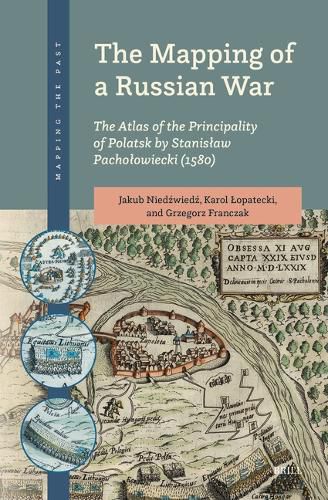
This volume is a comprehensive analysis of the Atlas of the Principality of Polatsk (1580), one of the oldest cartographic representations of the military conflict between Russia (Muscovy) and the Western world.
Its author, the Polish royal cartographer Stanislaw Pacholowiecki, drew the maps at the beginning of the Livonian War (1579-1582) when the Polish-Lithuanian army liberated the Lithuanian and Livonian lands from Muscovian occupation.
The Mapping of a Russian War focuses on the military aspects of the maps, their political and propaganda use, and the Early Modern construction of the past through maps.
The authors present an innovative approach to these maps, rarely examined by the international research community.
$9.00 standard shipping within Australia
FREE standard shipping within Australia for orders over $100.00
Express & International shipping calculated at checkout
This volume is a comprehensive analysis of the Atlas of the Principality of Polatsk (1580), one of the oldest cartographic representations of the military conflict between Russia (Muscovy) and the Western world.
Its author, the Polish royal cartographer Stanislaw Pacholowiecki, drew the maps at the beginning of the Livonian War (1579-1582) when the Polish-Lithuanian army liberated the Lithuanian and Livonian lands from Muscovian occupation.
The Mapping of a Russian War focuses on the military aspects of the maps, their political and propaganda use, and the Early Modern construction of the past through maps.
The authors present an innovative approach to these maps, rarely examined by the international research community.
Search our extensive online catalogue.
