Readings Newsletter
Become a Readings Member to make your shopping experience even easier.
Sign in or sign up for free!
You’re not far away from qualifying for FREE standard shipping within Australia
You’ve qualified for FREE standard shipping within Australia
The cart is loading…


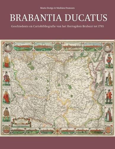
Deze inventarisatie van de gedrukte kaarten van het hertogdom Brabant omvat alle kaarten die gepubliceerd zijn tussen 1536, wanneer voor het eerst een kaart van Brabant wordt vermeld, en 1795, toen het feodale hertogdom werd opgeheven. De cartobibliografie betreft uitsluitend gedrukte kaarten, zowel houtsneden als koperdiepdrukken. In vier introductiehoofdstukken worden achtereenvolgens de geschiedenis van het hertogdom, de cartografie van het hertogdom, de wijzingen in het kaartbeeld in de loop van de tijd en de ontwikkeling van de nauwkeurigheid van kaarten met behulp van het programma MapAnalyst beschreven.
De cartobibliografie bevat kaarten van het hele hertogdom, de vier kwartieren, het noorden en het zuiden en een viertal historische kaarten. Alle kaarttitels zijn volledig, aangevuld met een toelichting, de publicatiewijze en een lijst van vindplaatsen, met nadruk op Nederland en Belgie.
This catalogue of printed maps of the Duchy of Brabant includes all the maps published between 1536, the date of the earliest mention of a map of Brabant, and 1795, when the feudal duchy was abolished. It includes woodcuts and intaglio prints. Four introductory chapters discribe the history of the duchy, the catrography of the duchy, the changes in the cartographic image over time and the evolution of the accuracy of the maps over time.
The cartobibliography contains maps of the entire duchy, maps of the four quarters, and maps of the north and south. All map titles are complete and supplemented with explanatory remarks, the manner of publication, and a list of locations where copies can be found, emphasizing the Netherlands and Belgium.
In Dutch, with an English summary.
$9.00 standard shipping within Australia
FREE standard shipping within Australia for orders over $100.00
Express & International shipping calculated at checkout
Deze inventarisatie van de gedrukte kaarten van het hertogdom Brabant omvat alle kaarten die gepubliceerd zijn tussen 1536, wanneer voor het eerst een kaart van Brabant wordt vermeld, en 1795, toen het feodale hertogdom werd opgeheven. De cartobibliografie betreft uitsluitend gedrukte kaarten, zowel houtsneden als koperdiepdrukken. In vier introductiehoofdstukken worden achtereenvolgens de geschiedenis van het hertogdom, de cartografie van het hertogdom, de wijzingen in het kaartbeeld in de loop van de tijd en de ontwikkeling van de nauwkeurigheid van kaarten met behulp van het programma MapAnalyst beschreven.
De cartobibliografie bevat kaarten van het hele hertogdom, de vier kwartieren, het noorden en het zuiden en een viertal historische kaarten. Alle kaarttitels zijn volledig, aangevuld met een toelichting, de publicatiewijze en een lijst van vindplaatsen, met nadruk op Nederland en Belgie.
This catalogue of printed maps of the Duchy of Brabant includes all the maps published between 1536, the date of the earliest mention of a map of Brabant, and 1795, when the feudal duchy was abolished. It includes woodcuts and intaglio prints. Four introductory chapters discribe the history of the duchy, the catrography of the duchy, the changes in the cartographic image over time and the evolution of the accuracy of the maps over time.
The cartobibliography contains maps of the entire duchy, maps of the four quarters, and maps of the north and south. All map titles are complete and supplemented with explanatory remarks, the manner of publication, and a list of locations where copies can be found, emphasizing the Netherlands and Belgium.
In Dutch, with an English summary.
Search our extensive online catalogue.
