Readings Newsletter
Become a Readings Member to make your shopping experience even easier.
Sign in or sign up for free!
You’re not far away from qualifying for FREE standard shipping within Australia
You’ve qualified for FREE standard shipping within Australia
The cart is loading…


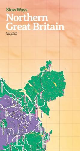
The map will be great for: imagining; planning journeys; drawing on; using as a companion to the website; marking Slow Ways you plan to walk; recording routes you have walked; learning about active travel in schools; making walls look fantastic! It is a two-sided giant, colourful and functional map. Slow Ways is an initiative to create a network of walking routes that connect all of Great Britain's towns and cities as well as thousands of villages and every national park. People can use the routes to walk between neighbouring places or combine routes to travel over longer distances. Slow Ways was kick-started during the first lockdown with hundreds of volunteers suggesting thousands of routes. There are now over 8,000 routes in the network that cover over 120,000km. Using the Slow Ways website, people are now walking the routes to make sure they are good enough to be in the network. Enough work has now been done to publish our first printed map of the network at a scale that is perfect for imagining, planning and recording journeys.
$9.00 standard shipping within Australia
FREE standard shipping within Australia for orders over $100.00
Express & International shipping calculated at checkout
The map will be great for: imagining; planning journeys; drawing on; using as a companion to the website; marking Slow Ways you plan to walk; recording routes you have walked; learning about active travel in schools; making walls look fantastic! It is a two-sided giant, colourful and functional map. Slow Ways is an initiative to create a network of walking routes that connect all of Great Britain's towns and cities as well as thousands of villages and every national park. People can use the routes to walk between neighbouring places or combine routes to travel over longer distances. Slow Ways was kick-started during the first lockdown with hundreds of volunteers suggesting thousands of routes. There are now over 8,000 routes in the network that cover over 120,000km. Using the Slow Ways website, people are now walking the routes to make sure they are good enough to be in the network. Enough work has now been done to publish our first printed map of the network at a scale that is perfect for imagining, planning and recording journeys.
Search our extensive online catalogue.
