Readings Newsletter
Become a Readings Member to make your shopping experience even easier.
Sign in or sign up for free!
You’re not far away from qualifying for FREE standard shipping within Australia
You’ve qualified for FREE standard shipping within Australia
The cart is loading…


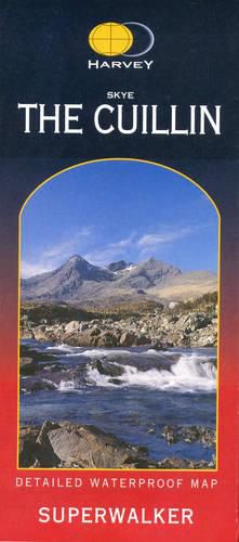
New Revised Edition and Format. More than a map, an essential piece of equipment this new generation HARVEY Superwalker is designed to be the most practical tool for navigation outdoors. The format gives more mapping on the sheet without making the map heavy and bulky. The fold has been developed to allow you to open directly to any part and either side of the sheet easily. No more struggling in the wind. The Superwalker XT25 is based on original HARVEY mapping with all the information a walker would expect on a map at 1:25,000 scale. Walls and fences on farmland are now shown. The clarity of the mapping has been improved to enable more people to read it without their glasses. The map is uncluttered by information irrelevant to the walker. The precise contouring and delicate hill shading give an immediate picture of the ground. Experience the satisfaction of fine navigation with the Superwalker XT25, now printed on our 100% waterproof and almost indestructible paper, whatever the weather! From Glen Brittle and the unique Black Cuillin in the west to the Red Cuillin and Broadford in the east. From the Sligachan Hotel and the A87 to the dramatic Loch Coruisk to the south. An enlargement of the Black Cuillin ridge at 1:12,500 scale is on the back of the map. This map for hillwalkers includes the Inn Pinn (Inaccessible Pinnacle), Am Basteir, Sgurr nan Gillean and Sgurr Alasdair among the 12 Munros,2 Corbetts and 5 Grahams.
$9.00 standard shipping within Australia
FREE standard shipping within Australia for orders over $100.00
Express & International shipping calculated at checkout
New Revised Edition and Format. More than a map, an essential piece of equipment this new generation HARVEY Superwalker is designed to be the most practical tool for navigation outdoors. The format gives more mapping on the sheet without making the map heavy and bulky. The fold has been developed to allow you to open directly to any part and either side of the sheet easily. No more struggling in the wind. The Superwalker XT25 is based on original HARVEY mapping with all the information a walker would expect on a map at 1:25,000 scale. Walls and fences on farmland are now shown. The clarity of the mapping has been improved to enable more people to read it without their glasses. The map is uncluttered by information irrelevant to the walker. The precise contouring and delicate hill shading give an immediate picture of the ground. Experience the satisfaction of fine navigation with the Superwalker XT25, now printed on our 100% waterproof and almost indestructible paper, whatever the weather! From Glen Brittle and the unique Black Cuillin in the west to the Red Cuillin and Broadford in the east. From the Sligachan Hotel and the A87 to the dramatic Loch Coruisk to the south. An enlargement of the Black Cuillin ridge at 1:12,500 scale is on the back of the map. This map for hillwalkers includes the Inn Pinn (Inaccessible Pinnacle), Am Basteir, Sgurr nan Gillean and Sgurr Alasdair among the 12 Munros,2 Corbetts and 5 Grahams.
Search our extensive online catalogue.
