Readings Newsletter
Become a Readings Member to make your shopping experience even easier.
Sign in or sign up for free!
You’re not far away from qualifying for FREE standard shipping within Australia
You’ve qualified for FREE standard shipping within Australia
The cart is loading…


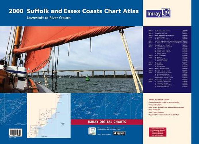
2000.1 Suffolk and Essex Coasts 1: 120 000 WGS 84
2000.2 Rivers Ore and Alde 1: 35 000 WGS 84
2000.3 River Deben and Orford Haven 1: 35 000 WGS 84 Plans Woodbridge, Tide Mill Yacht Harbour
2000.4 Harwich Approaches and Walton Backwaters 1: 35 000 WGS 84 Plans Walton Yacht Basin and Titchmarsh Marina
2000.5 Rivers Stour and Orwell 1: 35 000 WGS 84 Plans Upper Orwell to Ipswich, Fox’s Marina, Woolverstone Marina, Suffolk Yacht Harbour, Shotley Marina
2000.6 River Blackwater 1: 35 000 WGS 84 Plans Maldon, Tollesbury Marina, Bradwell Marina
2000.7 River Colne 1: 35 000 WGS 84 Plans Wivenhoe, Brightlingsea
2000.8 River Crouch Entrance 1: 35 000 WGS 84
2000.9 Rivers Crouch and Roach 1: 35 000 WGS 84 Plans Fambridge Yacht Haven, Bridgemarsh Marina, Burnham Yacht Harbour, Continuation of River Crouch
2000.10 Orford Ness to Lowestoft 1: 90 000 WGS 84 Plans Lowestoft Approaches, Lowestoft Harbour, Lowestoft Harbour - Lake Lothing, Southwold Harbour For this February 2018 edition the latest depth surveys have been applied. The latest wind farm information is included where relevant. There has been general updating throughout.
The 2018 edition is now wirobound and tidal stream information is included. Individual sheets of this atlas will no longer be sold separately. However, 1st edition charts Y2, Y6 and Y12 are to be published and are replicas of charts 2000.2, 2000.1 and 2000.5 respectively.
$9.00 standard shipping within Australia
FREE standard shipping within Australia for orders over $100.00
Express & International shipping calculated at checkout
2000.1 Suffolk and Essex Coasts 1: 120 000 WGS 84
2000.2 Rivers Ore and Alde 1: 35 000 WGS 84
2000.3 River Deben and Orford Haven 1: 35 000 WGS 84 Plans Woodbridge, Tide Mill Yacht Harbour
2000.4 Harwich Approaches and Walton Backwaters 1: 35 000 WGS 84 Plans Walton Yacht Basin and Titchmarsh Marina
2000.5 Rivers Stour and Orwell 1: 35 000 WGS 84 Plans Upper Orwell to Ipswich, Fox’s Marina, Woolverstone Marina, Suffolk Yacht Harbour, Shotley Marina
2000.6 River Blackwater 1: 35 000 WGS 84 Plans Maldon, Tollesbury Marina, Bradwell Marina
2000.7 River Colne 1: 35 000 WGS 84 Plans Wivenhoe, Brightlingsea
2000.8 River Crouch Entrance 1: 35 000 WGS 84
2000.9 Rivers Crouch and Roach 1: 35 000 WGS 84 Plans Fambridge Yacht Haven, Bridgemarsh Marina, Burnham Yacht Harbour, Continuation of River Crouch
2000.10 Orford Ness to Lowestoft 1: 90 000 WGS 84 Plans Lowestoft Approaches, Lowestoft Harbour, Lowestoft Harbour - Lake Lothing, Southwold Harbour For this February 2018 edition the latest depth surveys have been applied. The latest wind farm information is included where relevant. There has been general updating throughout.
The 2018 edition is now wirobound and tidal stream information is included. Individual sheets of this atlas will no longer be sold separately. However, 1st edition charts Y2, Y6 and Y12 are to be published and are replicas of charts 2000.2, 2000.1 and 2000.5 respectively.
Search our extensive online catalogue.
