Readings Newsletter
Become a Readings Member to make your shopping experience even easier.
Sign in or sign up for free!
You’re not far away from qualifying for FREE standard shipping within Australia
You’ve qualified for FREE standard shipping within Australia
The cart is loading…


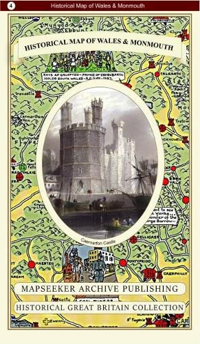
This folded map (890mm x 1000mm) pictorially illustrates the history of Wales and Monmouth. With historical locations and events illustrated pictorially in the form of charming cartoon vignettes, the map is surrounded by the armorial crests of Wales. The map was drawn by Leslie Bullock and first published c1966 by Collins Bartholomew as a fold-up map. This popular map from its time has now been re-digitized and republished in association with the Collins Bartholomew Archive using the latest printing technology. The print media used is 90 gsm Progeo paper which was specially developed as a map paper. It has high opacity to help reduce show through and a cross grain giving it greater durability to as the map is being folded.
$9.00 standard shipping within Australia
FREE standard shipping within Australia for orders over $100.00
Express & International shipping calculated at checkout
This folded map (890mm x 1000mm) pictorially illustrates the history of Wales and Monmouth. With historical locations and events illustrated pictorially in the form of charming cartoon vignettes, the map is surrounded by the armorial crests of Wales. The map was drawn by Leslie Bullock and first published c1966 by Collins Bartholomew as a fold-up map. This popular map from its time has now been re-digitized and republished in association with the Collins Bartholomew Archive using the latest printing technology. The print media used is 90 gsm Progeo paper which was specially developed as a map paper. It has high opacity to help reduce show through and a cross grain giving it greater durability to as the map is being folded.
Search our extensive online catalogue.
