Readings Newsletter
Become a Readings Member to make your shopping experience even easier.
Sign in or sign up for free!
You’re not far away from qualifying for FREE standard shipping within Australia
You’ve qualified for FREE standard shipping within Australia
The cart is loading…


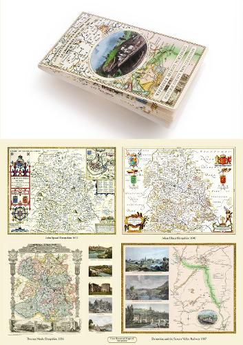
This folded map (890mm x 1000mm when unfolded) is an ideal souvenir for tourists to Shropshire and also a valuable reference resource for local and family history research. It includes 4 Historic maps of Shropshire, John Speed’s County Map of Shropshire 1611, Johan Blaeu’s County Map of Shropshire 1648, Thomas Moule’s County Map of Shropshire 1836 and a Map of Shropshire detailing the route of the Severn Vale Railway 1889. All the maps have been meticulously re-produced from antique originals and printed on 90 gsm Progeo paper which was specially developed as a map paper. It has high opacity to help reduce show through and a cross grain giving it greater durability to as the map is being folded.
$9.00 standard shipping within Australia
FREE standard shipping within Australia for orders over $100.00
Express & International shipping calculated at checkout
This folded map (890mm x 1000mm when unfolded) is an ideal souvenir for tourists to Shropshire and also a valuable reference resource for local and family history research. It includes 4 Historic maps of Shropshire, John Speed’s County Map of Shropshire 1611, Johan Blaeu’s County Map of Shropshire 1648, Thomas Moule’s County Map of Shropshire 1836 and a Map of Shropshire detailing the route of the Severn Vale Railway 1889. All the maps have been meticulously re-produced from antique originals and printed on 90 gsm Progeo paper which was specially developed as a map paper. It has high opacity to help reduce show through and a cross grain giving it greater durability to as the map is being folded.
Search our extensive online catalogue.
