Readings Newsletter
Become a Readings Member to make your shopping experience even easier.
Sign in or sign up for free!
You’re not far away from qualifying for FREE standard shipping within Australia
You’ve qualified for FREE standard shipping within Australia
The cart is loading…


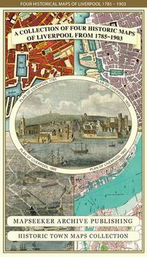
This folded map (890mm 1000mm when unfolded) is an ideal souvenir for tourists to Liverpool and also a valuable reference resource for local and family history research. The large map is titled A plan of the Town and Township of Liverpool 1785 by Charles Eves. It has been reproduced in full colour for the first time working from the very rare antique original. What makes this plan unique is the names of all of the land and property holders written across the parcels of land, yet to be built upon that surround the main town of Liverpool. The township of Everton is a distant village, well detached from Liverpool by open fields. The other three maps feature Cole and Ropers Plan of Liverpool from 1805, a Bird’s Eye View of Liverpool from 1866 and a more detailed Plan of Liverpool by Bartholomew showing the extensive Docklands in 1903. All the maps have been meticulously re-produced from antique originals and printed on 90 gsm Progeo paper which was specially developed as a map paper. It has high opacity to help reduce show through and a cross grain giving it greater durability to as the map is being folded.
$9.00 standard shipping within Australia
FREE standard shipping within Australia for orders over $100.00
Express & International shipping calculated at checkout
This folded map (890mm 1000mm when unfolded) is an ideal souvenir for tourists to Liverpool and also a valuable reference resource for local and family history research. The large map is titled A plan of the Town and Township of Liverpool 1785 by Charles Eves. It has been reproduced in full colour for the first time working from the very rare antique original. What makes this plan unique is the names of all of the land and property holders written across the parcels of land, yet to be built upon that surround the main town of Liverpool. The township of Everton is a distant village, well detached from Liverpool by open fields. The other three maps feature Cole and Ropers Plan of Liverpool from 1805, a Bird’s Eye View of Liverpool from 1866 and a more detailed Plan of Liverpool by Bartholomew showing the extensive Docklands in 1903. All the maps have been meticulously re-produced from antique originals and printed on 90 gsm Progeo paper which was specially developed as a map paper. It has high opacity to help reduce show through and a cross grain giving it greater durability to as the map is being folded.
Search our extensive online catalogue.
