Readings Newsletter
Become a Readings Member to make your shopping experience even easier.
Sign in or sign up for free!
You’re not far away from qualifying for FREE standard shipping within Australia
You’ve qualified for FREE standard shipping within Australia
The cart is loading…


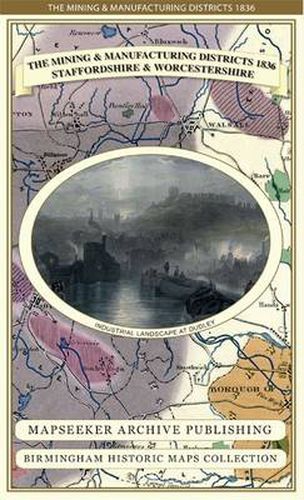
This is a detailed map of the Manufacturing District (Black Country) that shows in colour the coal field and other types of mineral mining areas. The map shows the canal network that had been constructed up to that time and when folded out measures 890mm x 1000mm. The canal network at this time was crucial for transportation of materials and goods across the district, just prior to the arrival of the railways. The map folds out to a large 1000m x 890mm size that is sharp and legible, a great resource for local history study. The map is printed on 90 gsm Progeo paper which was specially developed as a map paper. It has high opacity to help reduce show through and a cross grain giving it greater durability to as the map is being folded.
$9.00 standard shipping within Australia
FREE standard shipping within Australia for orders over $100.00
Express & International shipping calculated at checkout
This is a detailed map of the Manufacturing District (Black Country) that shows in colour the coal field and other types of mineral mining areas. The map shows the canal network that had been constructed up to that time and when folded out measures 890mm x 1000mm. The canal network at this time was crucial for transportation of materials and goods across the district, just prior to the arrival of the railways. The map folds out to a large 1000m x 890mm size that is sharp and legible, a great resource for local history study. The map is printed on 90 gsm Progeo paper which was specially developed as a map paper. It has high opacity to help reduce show through and a cross grain giving it greater durability to as the map is being folded.
Search our extensive online catalogue.
