Readings Newsletter
Become a Readings Member to make your shopping experience even easier.
Sign in or sign up for free!
You’re not far away from qualifying for FREE standard shipping within Australia
You’ve qualified for FREE standard shipping within Australia
The cart is loading…


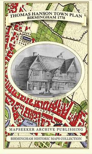
Folded Plan of Birmingham surveyed in 1778 by Thomas Hanson. This town plan clearly shows that a street pattern very similar to that of today was beginning to emerge. Buildings had now spread from Colmore Row as far out as the new church of St Paul’s, built to serve the growing population and designed by Roger Eykyn of Wolverhampton. Hanson’s survey is adorned with illustrations of key buildings. At the bottom right, Henry Bradford’s emerging Warner Fields estate is featured, stretching from the River Rea to Bordesley. Bradford Street ends at the river; the watercourse not only represented a physical barrier but also marked the limit of the estate and the parish boundary with Aston. The Canal Age , although short, would be responsible for opening up Britain to the Industrial Revolution. Hanson’s survey heralds the arrival of the canals in Birmingham. The town’s thriving industry is now connected with the coal mines of the nearby manufacturing districts, later to be known as the Black Country . The work has been created with kind permission of Birmingham Libraries and Archives in working from the original archive original, completely reworking to full colour. The paper stock used in this series of historic mapping is of a high quality developed especially for the printing of detailed mapping. The 90 gsm Progeo paper was specially developed as a map paper. It has high opacity to help reduce show through and a cross grain giving it greater durability as the map is being folded.
$9.00 standard shipping within Australia
FREE standard shipping within Australia for orders over $100.00
Express & International shipping calculated at checkout
Folded Plan of Birmingham surveyed in 1778 by Thomas Hanson. This town plan clearly shows that a street pattern very similar to that of today was beginning to emerge. Buildings had now spread from Colmore Row as far out as the new church of St Paul’s, built to serve the growing population and designed by Roger Eykyn of Wolverhampton. Hanson’s survey is adorned with illustrations of key buildings. At the bottom right, Henry Bradford’s emerging Warner Fields estate is featured, stretching from the River Rea to Bordesley. Bradford Street ends at the river; the watercourse not only represented a physical barrier but also marked the limit of the estate and the parish boundary with Aston. The Canal Age , although short, would be responsible for opening up Britain to the Industrial Revolution. Hanson’s survey heralds the arrival of the canals in Birmingham. The town’s thriving industry is now connected with the coal mines of the nearby manufacturing districts, later to be known as the Black Country . The work has been created with kind permission of Birmingham Libraries and Archives in working from the original archive original, completely reworking to full colour. The paper stock used in this series of historic mapping is of a high quality developed especially for the printing of detailed mapping. The 90 gsm Progeo paper was specially developed as a map paper. It has high opacity to help reduce show through and a cross grain giving it greater durability as the map is being folded.
Search our extensive online catalogue.
