Readings Newsletter
Become a Readings Member to make your shopping experience even easier.
Sign in or sign up for free!
You’re not far away from qualifying for FREE standard shipping within Australia
You’ve qualified for FREE standard shipping within Australia
The cart is loading…


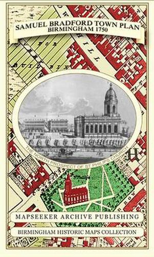
Folded Plan of Birmingham surveyed in 1750 by Samuel Bradford and engraved by Thomas Jeffery’s. Samuel Bradford, the son of Henry Bradford, a Quaker timber merchant, was born on 11th April 1725 and later became a surveyor. Land along what was to become Bradford Street, on the other side of the River Rea crossing at Deritend, was donated later by his father to anyone willing to establish a trade there. There is a list of the streets and lanes, with the number of houses and inhabitants in each. Colmore Row is now featured on this map for the first time, replacing New Hall Lane. Behind Colmore Row, named after the famous Colmore family that had resided for generations at New Hall, Charles Street, is just one of a number of streets being laid out for building. New Hall appears on the plan in its separate grandeur, although not for very much longer, with Newport Street running up its former access driveway. The top end of New Street, then named Swinford Street, is still bounded on both sides with land not yet built on. The work has been created with kind permission of Birmingham Libraries and Archives in working from the original archive original, completely reworking to full colour. The paper stock used in this series of historic mapping is of a high quality developed especially for the printing of detailed mapping. The 90 gsm Progeo paper was specially developed as a map paper. It has high opacity to help reduce show through and a cross grain giving it greater durability as the map is being folded.
$9.00 standard shipping within Australia
FREE standard shipping within Australia for orders over $100.00
Express & International shipping calculated at checkout
Folded Plan of Birmingham surveyed in 1750 by Samuel Bradford and engraved by Thomas Jeffery’s. Samuel Bradford, the son of Henry Bradford, a Quaker timber merchant, was born on 11th April 1725 and later became a surveyor. Land along what was to become Bradford Street, on the other side of the River Rea crossing at Deritend, was donated later by his father to anyone willing to establish a trade there. There is a list of the streets and lanes, with the number of houses and inhabitants in each. Colmore Row is now featured on this map for the first time, replacing New Hall Lane. Behind Colmore Row, named after the famous Colmore family that had resided for generations at New Hall, Charles Street, is just one of a number of streets being laid out for building. New Hall appears on the plan in its separate grandeur, although not for very much longer, with Newport Street running up its former access driveway. The top end of New Street, then named Swinford Street, is still bounded on both sides with land not yet built on. The work has been created with kind permission of Birmingham Libraries and Archives in working from the original archive original, completely reworking to full colour. The paper stock used in this series of historic mapping is of a high quality developed especially for the printing of detailed mapping. The 90 gsm Progeo paper was specially developed as a map paper. It has high opacity to help reduce show through and a cross grain giving it greater durability as the map is being folded.
Search our extensive online catalogue.
