Readings Newsletter
Become a Readings Member to make your shopping experience even easier.
Sign in or sign up for free!
You’re not far away from qualifying for FREE standard shipping within Australia
You’ve qualified for FREE standard shipping within Australia
The cart is loading…


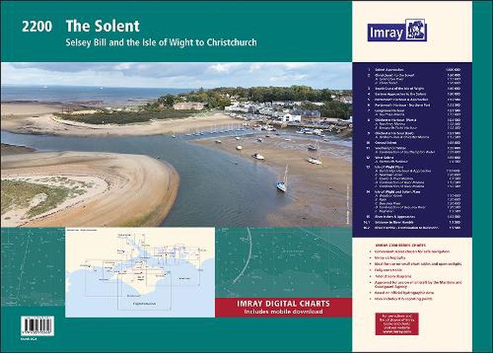
This fully revised and extended edition of our popular Solent chart pack has been redesigned and expanded to 16 sheets. It includes the latest official UKHO data combined with additional information sourced from Imray's network to make it ideal for small craft.
The chart pack includes all the navigational charts and tidal data for passage, approach and mooring. Included in this edition is improved coverage of the East Solent harbours.
Chichester, Langstone and Portsmouth Harbour are now shown across five new sheets allowing these harbours and approaches to be covered at a better scale. A new sheet has been added to show coastal navigation off the south coast of Isle of Wight, and a new index sheet of the Solent Approaches is now included.
New: Vessel Traffic Services (VTS) reporting points Imray charts for the Solent and approaches now include all VTS reporting points found in these waters. VTS reporting is mandatory for vessels of more than 20m in length that are bound to and from the Solent.
2200.1 Solent Approaches (1:300 000)
2200.2 Christchurch to the Solent (1:60 000) Plans: Lymington River (1:15 000) Christchurch (1:20 000) 2200.3 South Coast of the Isle of Wight (1:60 000)
2200.4 Eastern Approaches to the Solent (1:60 000)
2200.5 Portsmouth Harbour & Approaches (1:12 500)
2200.6 Portsmouth Harbour - Northern Part (1:12 500)
2200.7 Langstone Harbour (1:21 500) Plan: Southsea Marina (1:15 000)
2200.8 Chichester Harbour (West) (1:21 500) Plans: Northney Marina (1:12 500) Emsworth Yacht Harbour (1:12 500)
2200.9 Chichester Harbour (East) (1:21 500) Plan: Birdham Pool & Chichester Marina (1:12 500)
2200.10 Central Solent (1:35 000)
2200.11 Southampton Water (1:35 000) Plan: Continuation of Southampton Water (1:35 000)
2200.12 West Solent (1:35 000) Plan: Yarmouth Harbour (1:4500) 2200.13 Isle of Wight Plans Plans: Bembridge Harbour & Approaches (1:10 000), Newtown River (1:20 000), Cowes & River Medina (1:7500), Continuation of River Medina (1:12 500)
2200.14 Isle of Wight and Solent Plans Plans: Wootton Creek (1:10 000), Ryde (1:20 000), Beaulieu River (1:20 000), Keyhaven (1:7500)
2200.15 River Itchen & Approaches (1:12 500)
2200.16 River Hamble (1:7500)
$9.00 standard shipping within Australia
FREE standard shipping within Australia for orders over $100.00
Express & International shipping calculated at checkout
This fully revised and extended edition of our popular Solent chart pack has been redesigned and expanded to 16 sheets. It includes the latest official UKHO data combined with additional information sourced from Imray's network to make it ideal for small craft.
The chart pack includes all the navigational charts and tidal data for passage, approach and mooring. Included in this edition is improved coverage of the East Solent harbours.
Chichester, Langstone and Portsmouth Harbour are now shown across five new sheets allowing these harbours and approaches to be covered at a better scale. A new sheet has been added to show coastal navigation off the south coast of Isle of Wight, and a new index sheet of the Solent Approaches is now included.
New: Vessel Traffic Services (VTS) reporting points Imray charts for the Solent and approaches now include all VTS reporting points found in these waters. VTS reporting is mandatory for vessels of more than 20m in length that are bound to and from the Solent.
2200.1 Solent Approaches (1:300 000)
2200.2 Christchurch to the Solent (1:60 000) Plans: Lymington River (1:15 000) Christchurch (1:20 000) 2200.3 South Coast of the Isle of Wight (1:60 000)
2200.4 Eastern Approaches to the Solent (1:60 000)
2200.5 Portsmouth Harbour & Approaches (1:12 500)
2200.6 Portsmouth Harbour - Northern Part (1:12 500)
2200.7 Langstone Harbour (1:21 500) Plan: Southsea Marina (1:15 000)
2200.8 Chichester Harbour (West) (1:21 500) Plans: Northney Marina (1:12 500) Emsworth Yacht Harbour (1:12 500)
2200.9 Chichester Harbour (East) (1:21 500) Plan: Birdham Pool & Chichester Marina (1:12 500)
2200.10 Central Solent (1:35 000)
2200.11 Southampton Water (1:35 000) Plan: Continuation of Southampton Water (1:35 000)
2200.12 West Solent (1:35 000) Plan: Yarmouth Harbour (1:4500) 2200.13 Isle of Wight Plans Plans: Bembridge Harbour & Approaches (1:10 000), Newtown River (1:20 000), Cowes & River Medina (1:7500), Continuation of River Medina (1:12 500)
2200.14 Isle of Wight and Solent Plans Plans: Wootton Creek (1:10 000), Ryde (1:20 000), Beaulieu River (1:20 000), Keyhaven (1:7500)
2200.15 River Itchen & Approaches (1:12 500)
2200.16 River Hamble (1:7500)
Search our extensive online catalogue.
