Readings Newsletter
Become a Readings Member to make your shopping experience even easier.
Sign in or sign up for free!
You’re not far away from qualifying for FREE standard shipping within Australia
You’ve qualified for FREE standard shipping within Australia
The cart is loading…


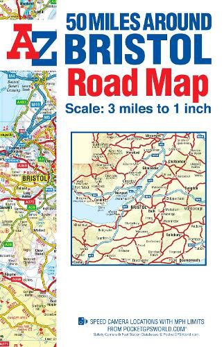
This A-Z 50 Miles around Bristol map is a full colour, single sided, fold-out road map featuring continuous mapping extending to include Worcester and Stratford-upon-Avon to the north, Witney and Andover to the east, Bournemouth and Lyme Regis to the south and Minehead and Bridgend to the west.
Published at a clear 3 miles to 1 inch the following features are shown on the road mapping: Motorways open with full junction detail, motorways under construction and proposed, service areas, primary routes and destinations, A & B roads, selected minor roads, gradients 1:5 and steeper, tolls, mileages, national and county boundaries, spot heights and hill shading. Selected safety camera locations with maximum speed limits. Selected fuel stations. A wide range of ancillary and tourist information. Brecon Beacons, New Forest and Exmoor National Park boundaries.
The index to cities, towns, villages, hamlets and locations is adjacent to the map.
$9.00 standard shipping within Australia
FREE standard shipping within Australia for orders over $100.00
Express & International shipping calculated at checkout
This A-Z 50 Miles around Bristol map is a full colour, single sided, fold-out road map featuring continuous mapping extending to include Worcester and Stratford-upon-Avon to the north, Witney and Andover to the east, Bournemouth and Lyme Regis to the south and Minehead and Bridgend to the west.
Published at a clear 3 miles to 1 inch the following features are shown on the road mapping: Motorways open with full junction detail, motorways under construction and proposed, service areas, primary routes and destinations, A & B roads, selected minor roads, gradients 1:5 and steeper, tolls, mileages, national and county boundaries, spot heights and hill shading. Selected safety camera locations with maximum speed limits. Selected fuel stations. A wide range of ancillary and tourist information. Brecon Beacons, New Forest and Exmoor National Park boundaries.
The index to cities, towns, villages, hamlets and locations is adjacent to the map.
Search our extensive online catalogue.
