Readings Newsletter
Become a Readings Member to make your shopping experience even easier.
Sign in or sign up for free!
You’re not far away from qualifying for FREE standard shipping within Australia
You’ve qualified for FREE standard shipping within Australia
The cart is loading…


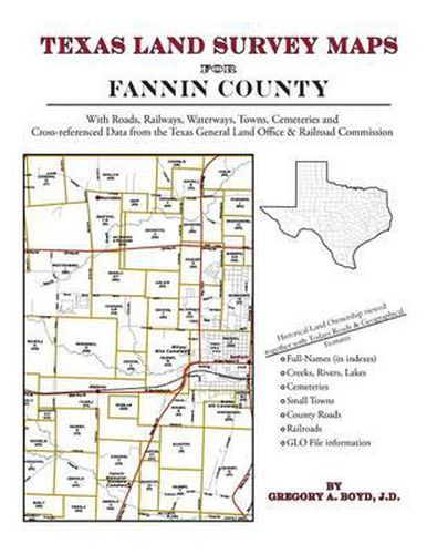
208 pages with 54 maps An indispensable book for any researcher interested in Fannin County’s history or land (or both), or its first landowners after Texas’s Independence from Mexico. Each book in this series is laid out into multiple maps using a 6 mile high by 4 mile wide grid.This book contains 49 Survey maps laid out within this grid. Each Land Survey Map shows the boundaries of original parcels laid out over existing roads, railroads, waterways. These are shown as well as the original Survey-Name and the Abstract Number assigned by the Texas General Land Office to the instrument that gave ownership to that parcel. Here are a number of details about our Fannin County book … Supplemental Maps Included (in addition to the primary Survey Maps) … - Where Fannin County Lies Within the State (Map A) - Fannin County and its Surrounding Counties (Map B) - An Index Map showing where each of the Land Survey Maps are within Fannin County (Map C) - An Index Map that builds upon Map C and shows the community-center points in relationship to the county-grid (Map D) - An Index Map that builds upon Map C and shows cemeteries listed in the USGS database in relationship to the county-grid (Map E) Primary Indexes (apart from each Survey-Map’s own index of survey-names) - An All-Name Index (alphabetical by last-name) for every person mentioned in the maps, utilizing both Texas General Land Office and Texas Railroad Commission data. - The Abstract Listing: this is where you find the real details behind each parcel of land.Items are listed by Abstract Number What Cities and Towns are in Fannin County, Texas (and in this book)? Allen Point, Allens Chapel, Anthony, Bagby, Bailey, Bartley Woods, Bettis, Bonham, Boyd, Brotherton, Bug Tussle, Burnett, Carson, Clutter Point, Cotton Center, Danner, Delba, Dial, Dodd City, Dotson, Duplex, Ector, Edhube, Elwood, Ely, English, Enterprise, Finley, Flag Springs, Flat Prairie, Gober, Hail, Hilger, Honey Grove, Hudsonville, Ivanhoe, Ladonia, Lamasco, Lannius, Leonard, Lyday Crossing, Midway, Monkstown, Mulberry, Newt, Nobility, Nunnelee, Oak Ridge, Oakland, Orangeville, Pettigrew, Pleasant Grove, Post Oak, Prairie Point, Randolph, Ravenna, Ridings, Riverby, Rogers, Sash, Savoy, Selfs, Shady Grove, Silver City, Sowells Bluff, Spring Hill, Telephone, Trenton, Tulip, Union Hill, White Rock, White Shed, Windom
$9.00 standard shipping within Australia
FREE standard shipping within Australia for orders over $100.00
Express & International shipping calculated at checkout
208 pages with 54 maps An indispensable book for any researcher interested in Fannin County’s history or land (or both), or its first landowners after Texas’s Independence from Mexico. Each book in this series is laid out into multiple maps using a 6 mile high by 4 mile wide grid.This book contains 49 Survey maps laid out within this grid. Each Land Survey Map shows the boundaries of original parcels laid out over existing roads, railroads, waterways. These are shown as well as the original Survey-Name and the Abstract Number assigned by the Texas General Land Office to the instrument that gave ownership to that parcel. Here are a number of details about our Fannin County book … Supplemental Maps Included (in addition to the primary Survey Maps) … - Where Fannin County Lies Within the State (Map A) - Fannin County and its Surrounding Counties (Map B) - An Index Map showing where each of the Land Survey Maps are within Fannin County (Map C) - An Index Map that builds upon Map C and shows the community-center points in relationship to the county-grid (Map D) - An Index Map that builds upon Map C and shows cemeteries listed in the USGS database in relationship to the county-grid (Map E) Primary Indexes (apart from each Survey-Map’s own index of survey-names) - An All-Name Index (alphabetical by last-name) for every person mentioned in the maps, utilizing both Texas General Land Office and Texas Railroad Commission data. - The Abstract Listing: this is where you find the real details behind each parcel of land.Items are listed by Abstract Number What Cities and Towns are in Fannin County, Texas (and in this book)? Allen Point, Allens Chapel, Anthony, Bagby, Bailey, Bartley Woods, Bettis, Bonham, Boyd, Brotherton, Bug Tussle, Burnett, Carson, Clutter Point, Cotton Center, Danner, Delba, Dial, Dodd City, Dotson, Duplex, Ector, Edhube, Elwood, Ely, English, Enterprise, Finley, Flag Springs, Flat Prairie, Gober, Hail, Hilger, Honey Grove, Hudsonville, Ivanhoe, Ladonia, Lamasco, Lannius, Leonard, Lyday Crossing, Midway, Monkstown, Mulberry, Newt, Nobility, Nunnelee, Oak Ridge, Oakland, Orangeville, Pettigrew, Pleasant Grove, Post Oak, Prairie Point, Randolph, Ravenna, Ridings, Riverby, Rogers, Sash, Savoy, Selfs, Shady Grove, Silver City, Sowells Bluff, Spring Hill, Telephone, Trenton, Tulip, Union Hill, White Rock, White Shed, Windom
Search our extensive online catalogue.
