Readings Newsletter
Become a Readings Member to make your shopping experience even easier.
Sign in or sign up for free!
You’re not far away from qualifying for FREE standard shipping within Australia
You’ve qualified for FREE standard shipping within Australia
The cart is loading…


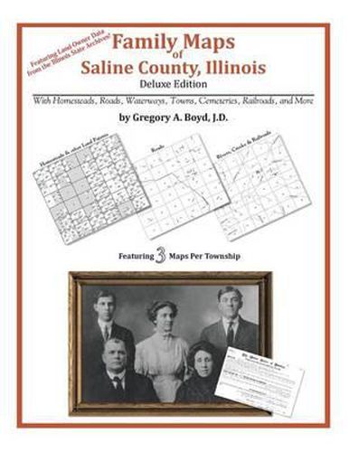
220 pages with 41 total maps Locating original landowners in maps has never been an easy task-until now. This volume in the Family Maps series contains newly created maps of original landowners (patent maps) in what is now Saline County, Illinois, gleaned from the indexes of the Illinois State Archives. But it offers much more than that. For each township in the county, there are two additional maps accompanying the patent map: a road map and a map showing waterways, railroads, and both modern and many historical city-centers and cemeteries. Included are indexes to help you locate what you are looking for, whether you know a person’s name, a last name, a place-name, or a cemetery. The combination of maps and indexes are designed to aid researchers of American history or genealogy to explore frontier neighborhoods, examine family migrations, locate hard-to-find cemeteries and towns, as well as locate land based on legal descriptions found in old documents or deeds. The patent-maps are essentially plat maps but instead of depicting owners for a particular year, these maps show original landowners, no matter when the transfer from the federal government was completed. Dates of patents typically begin near the time of statehood and run into the early 1900s. What’s Mapped in this book (that you’ll not likely find elsewhere) … 4401 Parcels of Land (with original landowner names and patent-dates labeled in the relevant map) 44 Cemeteries plus … Roads, and existing Rivers, Creeks, Streams, Railroads, and Small-towns (including some historical), etc. What YEARS are these maps for? Here are the counts for parcels of land mapped, by the decade in which the patent applications were made: DecadeParcel-count 1810s127 1820s54 1830s1134 1840s343 1850s3019 1860s15 1870s2 1880s5 1980s1 What Cities and Towns are in Saline County, Illinois (and in this book)? Beulah Heights, Buena Vista, Carrier Mills, Cottage Grove, Delta, Derby, Dorris Heights, Dorrisville, Eagle, Eldorado, Francis, Galatia, Garden Heights, Gaskins City, Halltown (historical), Harco, Harrisburg, Horseshoe, Ledford, Liberty, Long Branch, Mitchellsville, Muddy, New Hope, Newcastle, Oldtown, Pankeyville, Raleigh, Red Bud (historical), Rudement, Saline, Saline City, Saline Valley Store (historical), Somerset, Texas City, Tison, Wasson, West End, Whitesville (historical)
$9.00 standard shipping within Australia
FREE standard shipping within Australia for orders over $100.00
Express & International shipping calculated at checkout
220 pages with 41 total maps Locating original landowners in maps has never been an easy task-until now. This volume in the Family Maps series contains newly created maps of original landowners (patent maps) in what is now Saline County, Illinois, gleaned from the indexes of the Illinois State Archives. But it offers much more than that. For each township in the county, there are two additional maps accompanying the patent map: a road map and a map showing waterways, railroads, and both modern and many historical city-centers and cemeteries. Included are indexes to help you locate what you are looking for, whether you know a person’s name, a last name, a place-name, or a cemetery. The combination of maps and indexes are designed to aid researchers of American history or genealogy to explore frontier neighborhoods, examine family migrations, locate hard-to-find cemeteries and towns, as well as locate land based on legal descriptions found in old documents or deeds. The patent-maps are essentially plat maps but instead of depicting owners for a particular year, these maps show original landowners, no matter when the transfer from the federal government was completed. Dates of patents typically begin near the time of statehood and run into the early 1900s. What’s Mapped in this book (that you’ll not likely find elsewhere) … 4401 Parcels of Land (with original landowner names and patent-dates labeled in the relevant map) 44 Cemeteries plus … Roads, and existing Rivers, Creeks, Streams, Railroads, and Small-towns (including some historical), etc. What YEARS are these maps for? Here are the counts for parcels of land mapped, by the decade in which the patent applications were made: DecadeParcel-count 1810s127 1820s54 1830s1134 1840s343 1850s3019 1860s15 1870s2 1880s5 1980s1 What Cities and Towns are in Saline County, Illinois (and in this book)? Beulah Heights, Buena Vista, Carrier Mills, Cottage Grove, Delta, Derby, Dorris Heights, Dorrisville, Eagle, Eldorado, Francis, Galatia, Garden Heights, Gaskins City, Halltown (historical), Harco, Harrisburg, Horseshoe, Ledford, Liberty, Long Branch, Mitchellsville, Muddy, New Hope, Newcastle, Oldtown, Pankeyville, Raleigh, Red Bud (historical), Rudement, Saline, Saline City, Saline Valley Store (historical), Somerset, Texas City, Tison, Wasson, West End, Whitesville (historical)
Search our extensive online catalogue.
