Readings Newsletter
Become a Readings Member to make your shopping experience even easier.
Sign in or sign up for free!
You’re not far away from qualifying for FREE standard shipping within Australia
You’ve qualified for FREE standard shipping within Australia
The cart is loading…


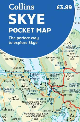
Handy little full colour Collins map of Skye with a high level of detail. Clear mapping of the Isle of Skye showing the road network, ferries and places of interest. Map at a scale of 1:175 000 (3 miles to 1 inch).
Clear, detailed, full colour Collins road mapping is presented in a handy format ideal for the pocket or handbag. It is excellent value and covers the whole of the Isle of Skye.
This map includes: * Scotland route map * Caravan and camping sites * Tourist locations * Ferry links * Listing of major places to visit, with additional details for Dunvegan Castle, Old Man of Storr and Loch Coruisk * Detailed place names index
$9.00 standard shipping within Australia
FREE standard shipping within Australia for orders over $100.00
Express & International shipping calculated at checkout
Handy little full colour Collins map of Skye with a high level of detail. Clear mapping of the Isle of Skye showing the road network, ferries and places of interest. Map at a scale of 1:175 000 (3 miles to 1 inch).
Clear, detailed, full colour Collins road mapping is presented in a handy format ideal for the pocket or handbag. It is excellent value and covers the whole of the Isle of Skye.
This map includes: * Scotland route map * Caravan and camping sites * Tourist locations * Ferry links * Listing of major places to visit, with additional details for Dunvegan Castle, Old Man of Storr and Loch Coruisk * Detailed place names index
Search our extensive online catalogue.
