


A Collection of Four Historic Maps of Worcestershire
A Collection of Four Historic Maps of Worcestershire
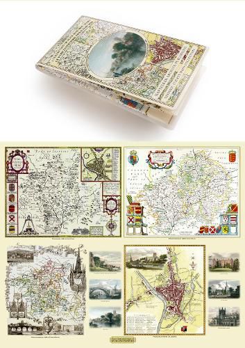
This folded map (890mm x 1000mm when unfolded) is an ideal souvenir for tourists to Worcestershire and also a valuable reference resource for local and family history research. It includes 4 Historic maps of Worcestershire, John Speed's County Map of Worcestershire 1611, Johan Blaeu's County Map of Worcestershire 1648,Thomas Moule's County Map of Worcestershire 1836 and the detailed Plan of the City of Worcester by Cole and Roper 1805. All the maps have been meticulously re-produced from antique originals and printed on 90 gsm "Progeo" paper which was specially developed as a map paper. It has high opacity to help reduce show through and a cross grain giving it greater durability to as the map is being folded.
This item is not currently in-stock. It can be ordered online and is expected to ship in approx 2 weeks
Our stock data is updated periodically, and availability may change throughout the day for in-demand items. Please call the relevant shop for the most current stock information. Prices are subject to change without notice.
Sign in or become a Readings Member to add this title to a wishlist.