


A Collection of Four Historic Maps of Sussex from 1611 - 1851
Mapseeker Publishing Ltd Mapseeker Publishing Ltd
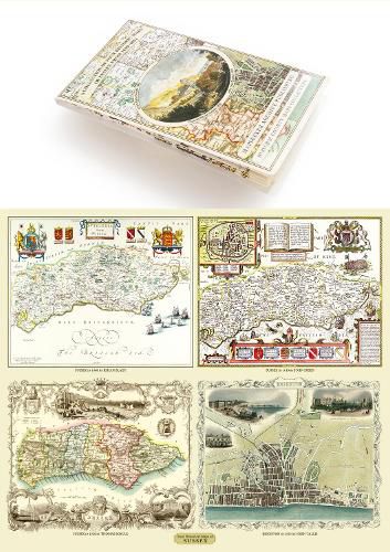
A Collection of Four Historic Maps of Sussex from 1611 - 1851
Mapseeker Publishing Ltd Mapseeker Publishing Ltd
This folded map (890mm x 1000mm when unfolded) is an ideal souvenir for tourists to Sussex and also a valuable reference resource for local and family history research. It includes 4 Historic maps of Sussex, John Speed’s County Map of Sussex 1610, Johan Blaeu’s County Map of Sussex 1648,Thomas Moule’s County Map of Sussex 1836 and a detailed Plan of Brighton by John Tallis 1851. All the maps have been meticulously re-produced from antique originals and printed on 90 gsm Progeo paper which was specially developed as a map paper. It has high opacity to help reduce show through and a cross grain giving it greater durability to as the map is being folded.
This item is not currently in-stock. It can be ordered online and is expected to ship in approx 2 weeks
Our stock data is updated periodically, and availability may change throughout the day for in-demand items. Please call the relevant shop for the most current stock information. Prices are subject to change without notice.
Sign in or become a Readings Member to add this title to a wishlist.